Best of 2020: An Ordinary Intersection
Google Street View was launched the month I graduated from college. Maybe that just means that I'm older than I want to admit to myself, but it's astonishing to me how quickly I've come to take for granted that I can, from my living room, take a walking tour of the lively streets of Plovdiv, Bulgaria or Denpasar, Indonesia, or a scenic drive along a Norwegian fjord. It's absolutely awful for work productivity—except when it isn't. Because the truth is, Google has also created an amazing research and communication tool for anyone interested in urban design and its implications for how we live.
We've put it to good use at Strong Towns. This year we published a stunning look at the literal disappearance of whole blocks worth of houses in Detroit, a consequence of draconian tax foreclosure policies in the wake of the 2008 housing crash. It's Street View as urban archaeology. We also used the case study of El Alto, Bolivia, to examine the economics of traditional, incremental development—all thanks to Google. That's not even considering the more casual use of Street View imagery in literally hundreds of articles, where a picture saves a thousand words.
The below essay, “An Ordinary Intersection,” wouldn't exist without Street View, and it came about entirely by accident. I was reading an excellent Curbed article by Patrick Sisson about the deadly roads of Orlando, Florida—probably the worst city in America in which to be a pedestrian—and the efforts of a few reformers to swim against the current of a car-centric culture that regards people who walk as afterthoughts at best. Out of pure curiosity, I Googled an intersection mentioned in Sisson's essay, and my jaw dropped. The Street View car had driven through the area right as a nearby high school let out, and in the Google photos, clear as day, you can see dozens of students expected to make do with walking home alongside high-speed traffic in an absolutely miserable, unsafe, and degrading environment.
Such environments exist all over North America, and millions of people have this same experience. But had I intentionally gone looking to document it in photos of my own, it would have been a major photojournalism project involving a field trip or several. In this case, the sheer volume of knowledge encapsulated in Google's database makes it easier to broaden not only our understanding of the often-insane world we have built, but hopefully our appetite to change it. — Daniel Herriges, Senior Editor
Curbed's Patrick Sisson has an excellent piece on Orlando, the almost undisputed capital of pedestrian carnage in the U.S., and just how its roads got so deadly.
It's a great examination of the multifaceted nature of the problem, which isn’t just about road design but about the design of suburbia as a place on a really fundamental level. We’ve built places so spread-out and disconnected that they don’t function unless you can drive 40 or 50 miles per hour. Metropolitan Orlando is almost entirely comprised of such places. Which means that improving safety isn’t merely a street engineering challenge, or an issue of coming up with the necessary funding. It’s a deep challenge to a whole ingrained, institutionalized way of building places, and Orlando’s transportation director, Billy Hattaway (a veteran of the Florida DOT who deserves a ton of credit for pushing it to improve its bicycle and pedestrian policies) seems to understand the fight that’s required:
Next year, Hattaway will start an even bigger process with potential for greater impact, rewriting development guidelines for the city. Hattaway showed me an infamous photo of a series of homes on cul-de-sacs designed for cars and not walkability, resulting in two adjacent homes requiring seven miles of roads to get from one to the other.
“All the activists and politicians have blamed transportation as being a source of the problem,” says Hattaway. “This is equally a land development problem. It’ll actually save us money, but it requires political will to stand up to the development community.”
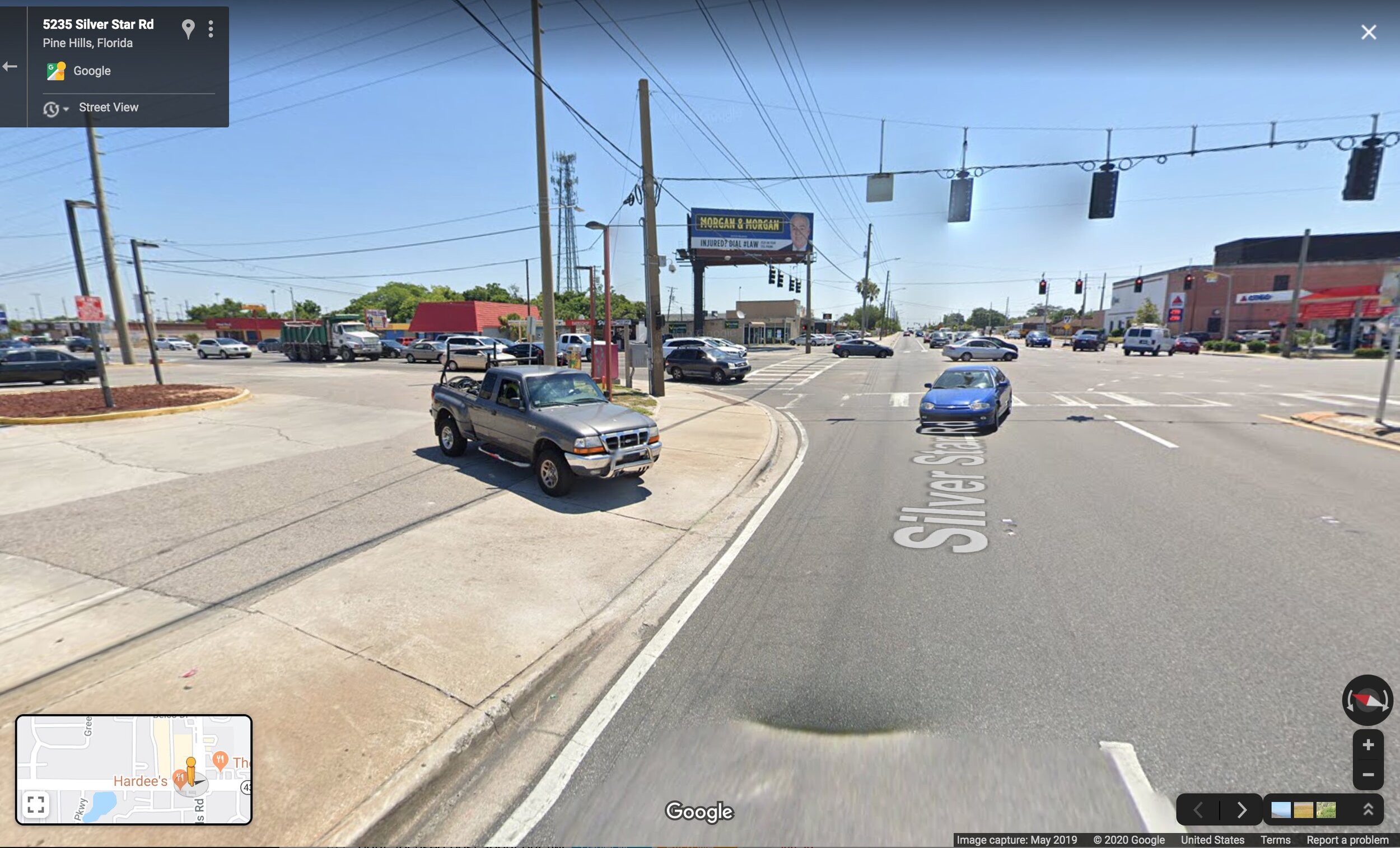
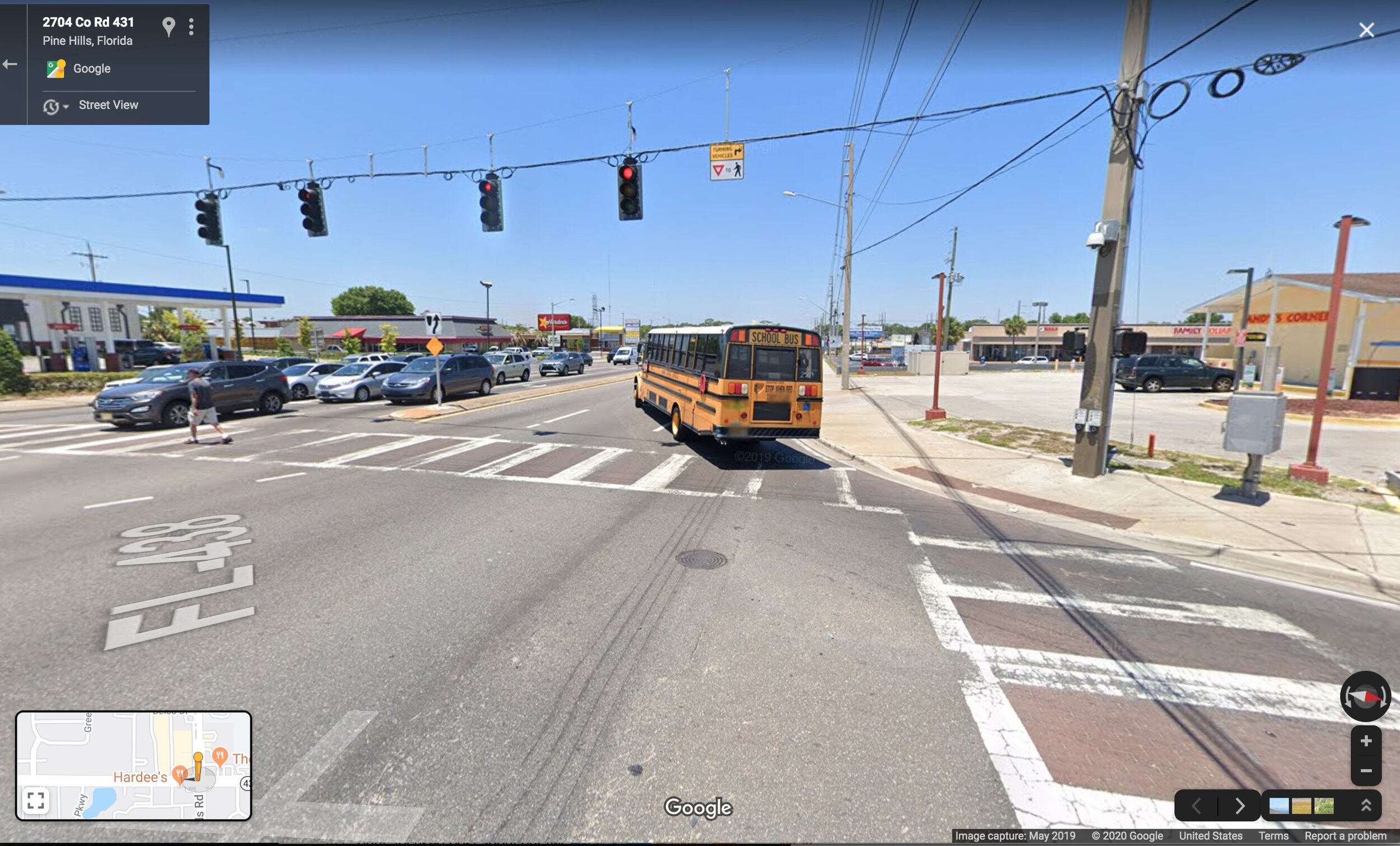
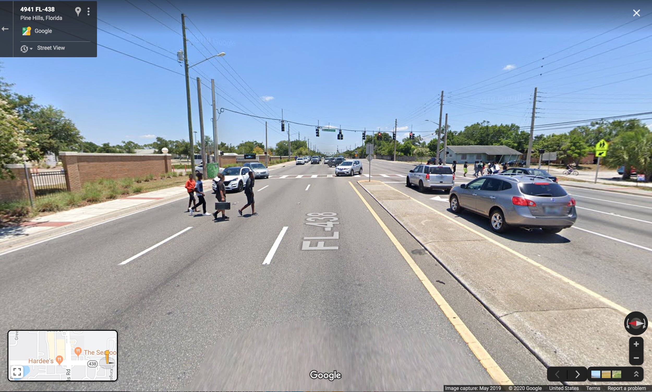
One later section of Sisson’s piece describes a particularly awful intersection in Pine Hills, an area I was mildly acquainted with. This made me curious, so I started poking around on Google Street View. You know, as one does.
It turns out the Google Street View car was there one day last May, right after the local high school (Maynard Evans) let out. Google has unwittingly created a photo essay of the conditions that teenagers leaving school onto Silver Star Road are expected to put up with. I present it to you here in slideshow form:
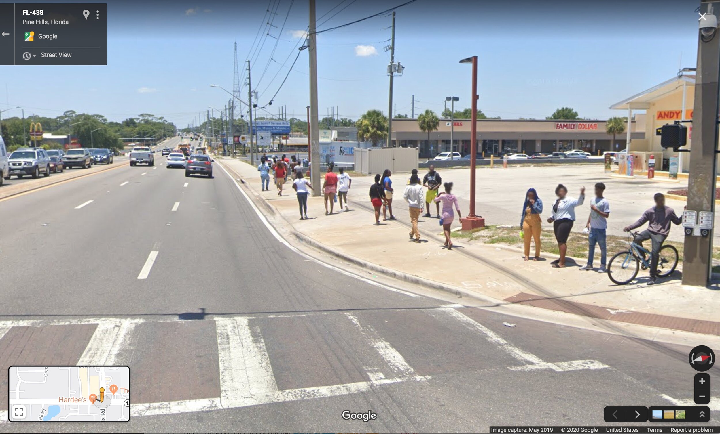
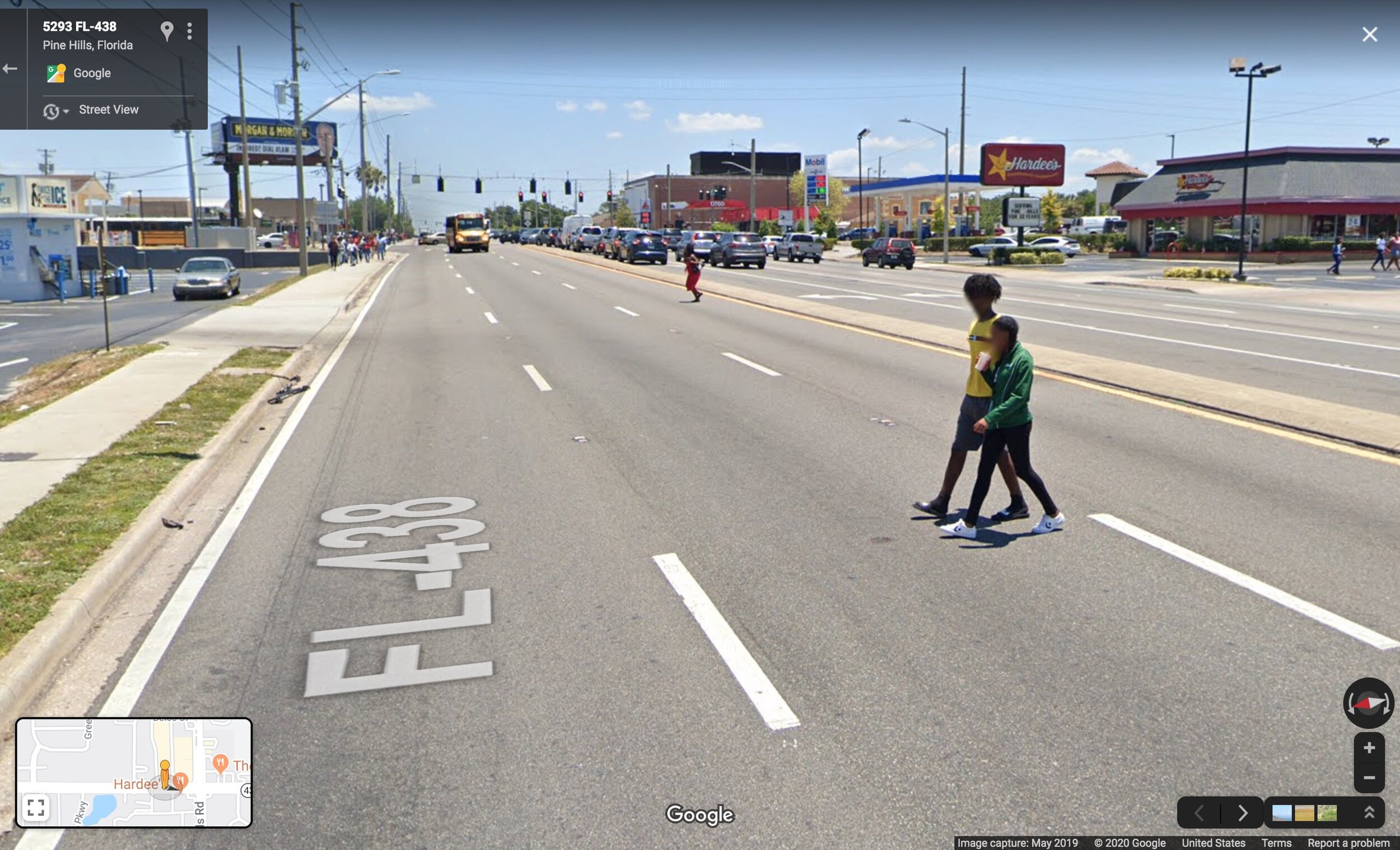
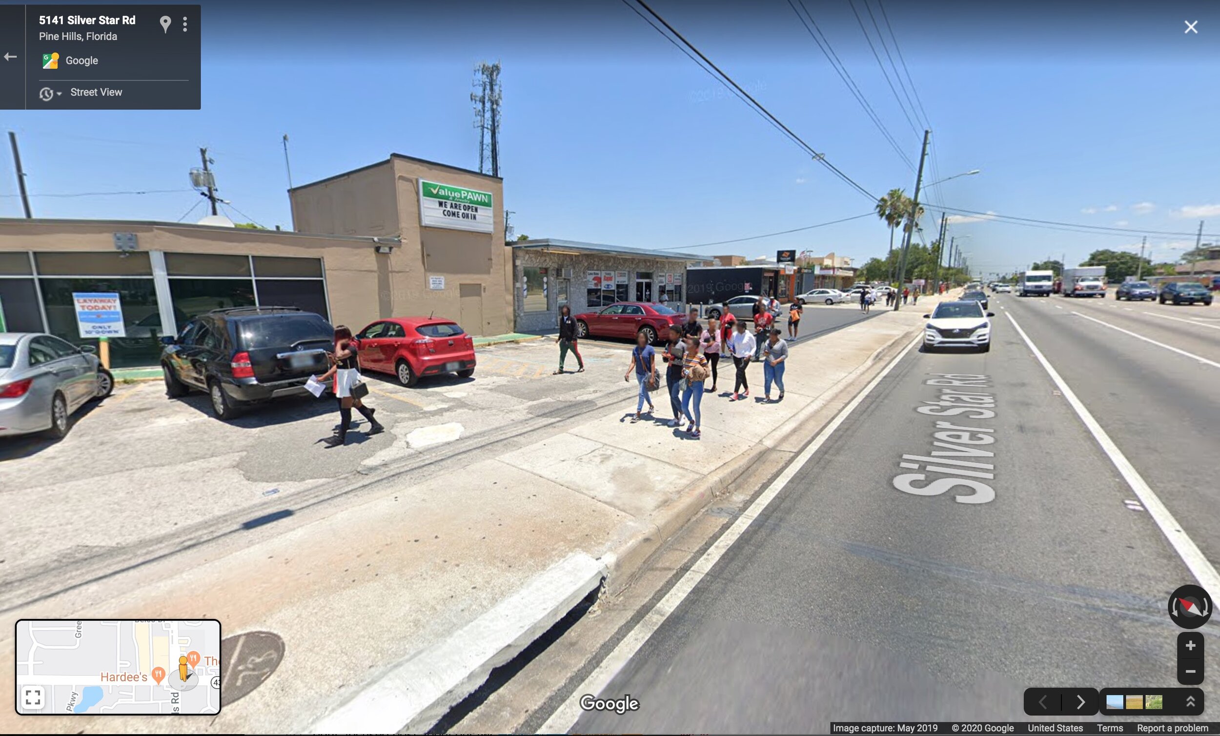
The Curbed piece quotes local bike/walk advocate Amanda Day explaining why people jaywalk here, and her explanation checks out with the Google photos:
Within an hour, we’d seen a man with a cane nearly get hit while shuffling across the road. Then Day herself, crossing with the signal, was almost struck by a car taking a right on red.
“This is why people don’t even cross at the main crosswalk,” she told me after recovering from the shock. “People simply gun it when they drive here. It’s safer to wait and cross in the middle of the block—at least they can see when cars are coming.”
If you think those pictures look like a tragedy waiting to happen, you're right. Google "pedestrian killed pine hills" and just scroll through the results page. It's numbing.
I also tried Googling "evans high school student hit by car." There too, I didn’t have to go further than the first page of search results. A senior at this school was killed in 2011—not in front of the school but on Vineland Road, a major Orlando stroad a few miles away. He was walking on the shoulder because there was no sidewalk. Jean Cherilus was an entrepreneur who sold sub sandwiches with "his mother's special sauce" to kids at school at lunch time. He was 17.
I knew before Googling I'd find a story like Jean's in no time. I just didn't know the particulars. You knew it too.
Car crashes are understood by most Americans as unavoidable tragedies. They are “just the way things are.” They’re the cost of modern living. Hopefully the photos from Street View illustrate that on Orlando's stroads (or feel free to substitute your city’s name) they're actually avoidable in a hundred different ways.
It’s clear that Hattaway and others are trying. Yet here’s another thing I knew I'd find before I found it: a history of utterly pathetic, inadequate responses to the area's safety crisis. Exhibit A: ticketing kids for jaywalking (2012). Exhibit B: recommending a phased release of students from school (this 2017 report). This is the culture Orlando’s street-safety reformers, inside and outside government, are fighting against: one in which anything other than actually slowing down traffic is what’s typically on the table.
Pine Hills is a low-income area home to Orlando's biggest Haitian population. Evans High School is 86% black, 10% white, and 11% Hispanic of any race. Low-income communities and people of color are disproportionately represented in fatal crashes involving people walking—in part because they disproportionately live in places where the infrastructure looks like those photos above.
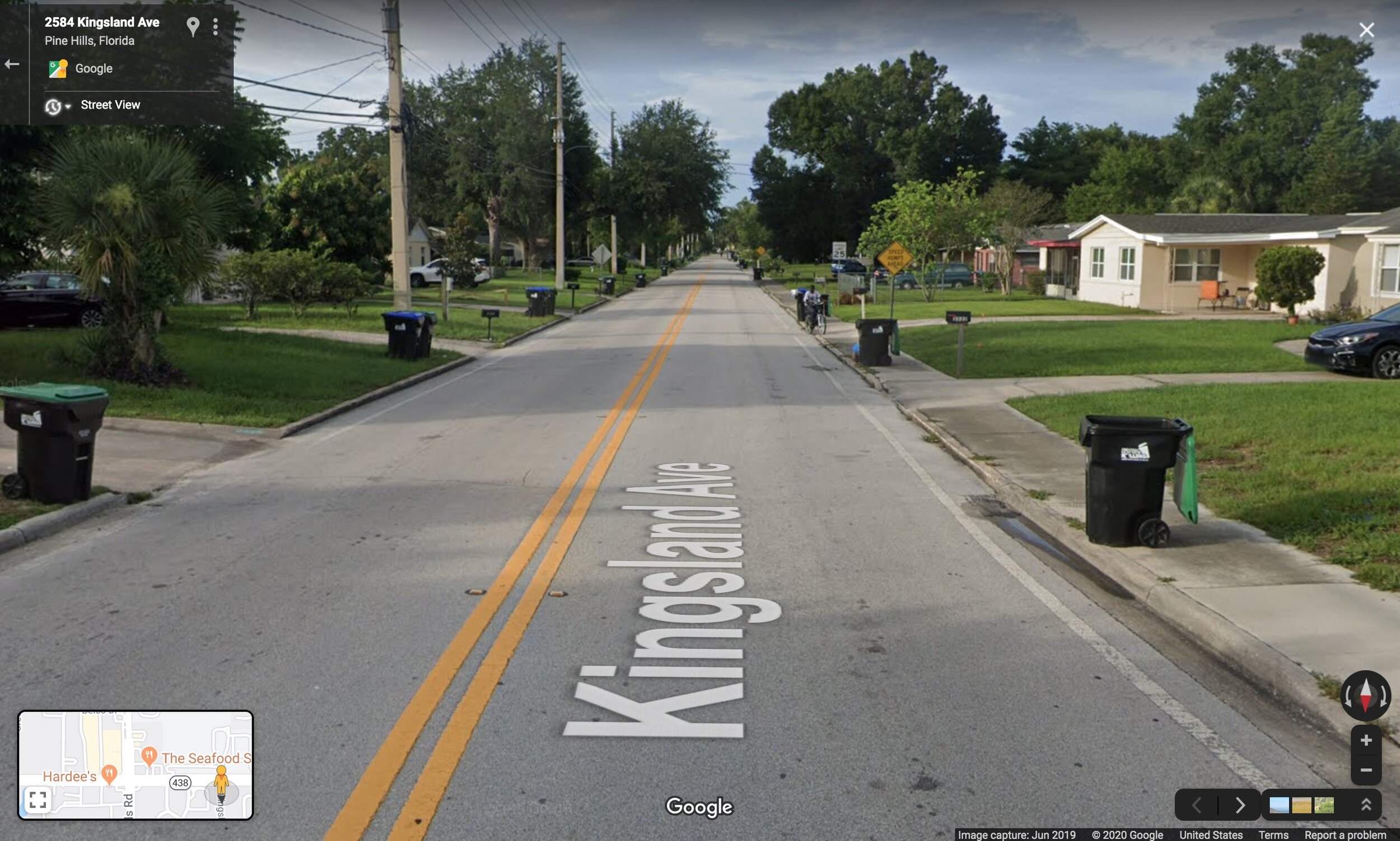
Something else I knew I'd find about Pine Hills—in broad strokes, not particulars—is this description of its history from Wikipedia:
The area that would become Pine Hills began in 1953. It was one of the first suburbs of Orlando and grew as a bedroom community for the workers of Martin Marietta (now Lockheed Martin). At the time, it was an upper-middle class suburb with a country club named "Silver Pines". Eventually, as Orlando's growth surrounded Pine Hills, many of the original families moved into newer neighborhoods in nearby Ocoee, Winter Garden and MetroWest.
Into the late 1980s and during the 1990s, Pine Hills fell into a state of decline. Silver Pines Country Club was closed, and apartment complexes were built on the property in the mid 1990s.[4] The "Pine Hills Shopping Center" lost its long-time tenants and was eventually converted in the late 1990s into "Pine Hills Marketplace", a strip mall with discount stores. As newer neighborhoods developed offering more housing options, rental rates dropped and housing became more affordable for residents. Neglect from Orange County government and little representation from Orange County Commissioners resulted in higher crime.
In other words, Pine Hills is an utterly typical fading inner-ring suburb of a type found all over the U.S. The "dominant industry is retail" (Wikipedia). When Pine Hills was built, it had one and exactly one selling point: affordable new houses. Now they're not new anymore.
The built environment here has clearly been a crucial factor in accelerating Pine Hills' decline. Drivers speed through a place like this on their way to elsewhere. Local businesses struggle to thrive on a road that functions like a drag strip. This is the stroad nation we’ve built: places where the roads themselves are undermining all efforts to build community, and to build wealth, on the land adjoining them.
This place is utterly normal. There are 1,000 suburbs like it in America, and 20,000 stroads like Silver Star Road. There are tens of thousands of schools on unsafe walking routes, and hundreds of thousands of intersections like this one.
The things that ought to be horrifying about this place are utterly normal. We just don't see them most of the time, least of all when we're the ones behind the windshield. But thankfully, Google happened to drive by Evans High School 10 minutes after school let out.
This is ordinary. This is the low bar we've set for what millions of Americans who don't drive get to deal with every day. We should all be angry and ashamed.
FREE EBOOK

Build Prosperity in Your Town, One Block at a Time
Walkable, people-oriented streets are the most economically productive form of development. Here’s how to create more prosperous and safe communities for everyone.


Conducting a walking audit is an quick, easy and free step that anyone can take to start improving their place. In this article, trained architect and urban designer Edward Erfurt demonstrates how to do so, using a recently completed sidewalk project in his community as an example.