Visualizing Place vs. Non-Place
It started with an actual, attention-grabbing point. Then, as is the way of all things Internet, it became a snarky meme. As is also the way of all things Internet, the meme has more to it than meets the eye.
A few years ago, our good friend Steve Mouzon (author of The Original Green) shared this graphic on his blog: a juxtaposition of the Renaissance-era core of Florence, Italy with a single freeway interchange in Atlanta, Georgia. It has made the rounds repeatedly in various urbanist and transportation circles ever since.
“The human brain is wired to understand distance in units of time—how often do you say, “It’s a few minutes away?” Because of this, when we’re moving at 40 or 70 miles per hour, it becomes incredibly difficult to intuitively grasp the actual amount of ground we’ve covering. ”
Mouzon’s graphic is intended to make a point about the gargantuan amount of land consumed by automobile infrastructure, particularly when it’s intended for high-speed driving. Speed requires wider turn radii, wider lanes, wider medians and shoulders, and buffer space to separate people and buildings from that fast, deadly traffic. The result: the same land area that could accommodate a bustling urban district of tens of thousands (Florence in 1425 had an estimated population of 60,000) is easily consumed by a single interchange.
Supersize that to the scale of a metro area like Atlanta’s, with all of its similar freeways and subsidiary feeder stroads, and you have a place where the actual destinations people want to get to are pushed so far apart by all this road space that it becomes inconceivable to travel between them without a car—necessitating even more land-hogging car infrastructure, in a vicious cycle.
Whatever “human scale” is—one imagines medieval Florence qualifies—it sure ain’t our modern highways. And yet, that profound difference in scale between the traditional and automobile city is something those who don’t spend their days staring at satellite maps are rarely given occasion to contemplate. The human brain is wired to understand distance in units of time—how often do you say, “It’s a few minutes away?” Because of this, when we’re moving along a freeway at 70 miles per hour, or even a stroad at 40, it becomes incredibly difficult to intuitively grasp the actual amount of ground we’ve covering. (True story: A friend of mine living in Orlando once unironically described her home a 15-minute freeway ride from where we were standing as “Just down the street.”)
You can easily make your own juxtaposition like Mouzon’s. One web based tool for doing so is Two Maps, One Scale. Fancier versions use an interactive slider bar, like this illustration by Strong Towns member Ryan Cooper of the amount of land devoted to the auto-centric design of a suburban mall versus gridded downtown Raleigh.
Mouzon’s graphic has made the rounds on the Internet since it was first published. Just recently, though, the two-cities, one-scale juxtaposition recently reappeared all over my social-media feeds, in the form of a sarcastic response to Mouzon’s orginal Atlanta-Florence meme. The sarcastic version looks like this:
Here’s a few more along the same lines, as compiled on Twitter by urbanist meme royalty Juliet Eldred:
Now we have the freeway outside of Florence, Amsterdam, or Barcelona, contrasted with the walkable gridded core of Atlanta, Los Angeles, or Miami Beach.
At surface level, this meme is an amusing critique of cherry picking. You can literally put any two cities in the world into those two boxes if you’re not concerned with whether the images you’ve chosen are representative of their places. And if your goal is to make a misleading point, you can certainly do that.
Does the fact that any such comparison is at least a little cherry-picked mean the two-maps, one-scale juxtaposition is worthless? Hardly.
The latest round of these memes also make another point: they highlight exactly the same thing about car infrastructure that Mouzon was highlighting. Only they do it while also reminding us that the world isn’t so simple as “Europe good, America bad,” a mindset which some U.S. urbanists are guilty of adopting. The Suburban Experiment didn’t only happen west of the Pond. Americans just did it first, and bigger, and more completely.
The Real Point: Places Versus Non-Places
This nomenclature was introduced to Strong Towns by longtime contributor Andrew Price, and I keep coming back to it as a way of thinking about the world, because of its simple but profound implications.
A place is anywhere that people want to be and might linger—a building containing homes or businesses, a library or school, a sidewalk, a public square, a park, a farm.
A non-place is anywhere that people aren’t going to linger—either it’s devoted to getting them from place to place, storing their vehicles, or it’s the filler in the landscape between our places. Examples of non-places are vehicle lanes, parking lots, freeways, as well as medians, retention ponds and all other sorts of landscaped buffers (often lumped together as “open space” in planning parlance) that serve to separate places from each other and mitigate their impacts on each other.
There is a whole world of nuance that I’m going to ignore right now by making this simple generalization:
As a rule of thumb, places create wealth. Non-places consume wealth.
In other words, for any sort of financially sustainable community, there’s a need to strike a balance between place and non-place. Too much non-place, and you’ve almost certainly got too much infrastructure to maintain and not enough actual tax revenue to do so.
It’s hard to have too much place. Traditional city districts, in fact, are often almost 100% place, because even the streets are platforms for human activity that, directly or indirectly, generates wealth. (I mean “wealth” in the broadest sense of the word, too.) Here’s the core of Florence at ground level:
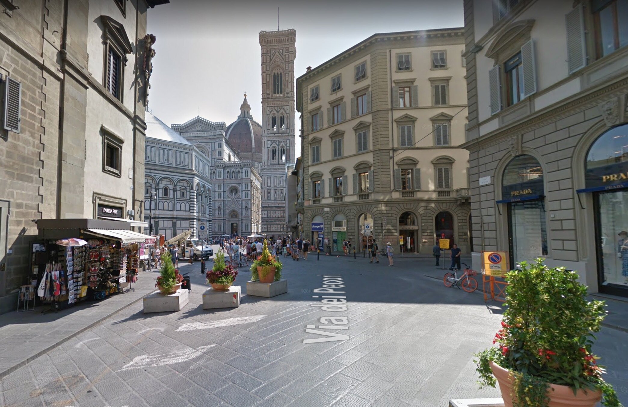
Click to explore on Google Street View.
The catch: It would be impossible to fit more than a few cars into this environment without ruining it. Accommodating cars is the number one thing humans do in our cities that requires non-places.
And accommodating a city where everyone travels by car, and many of them long distances, begins to require vast swaths of non-place: the point made so shockingly obvious by Mouzon’s Florence-vs-Atlanta graphic, considering how easy it is to not appreciate when you’re actually in Atlanta, driving around.
I routinely point out to people that the parking lot for a suburban big-box store is almost always larger than the store itself. Most are surprised—unless they’ve gone out with a camera and participated in #BlackFridayParking, they haven’t noticed. Once you do, it’s painfully obvious. We simply don’t think about it. It goes back to that inherent cognitive bias to perceive distance in time, not feet or miles.
This isn’t a “ban cars” argument. What we need is balance. We need to be able to pay for our transportation and other infrastructural systems as a whole—our places, at whatever local level of government we’re going to tax and fund them, need to generate enough revenue to maintain themselves over time. There are plenty of ways to do that with cars, and highways, as part of the transportation mix. Cars are almost unparalleled in their utility as a way of traveling quickly between productive cities and towns—which is why even in Europe, which has preserved much more of its traditional urbanism, you see Atlanta-like interchanges and freeways—you just see them on the beltways that ring major cities, and almost never in the city centers themselves.
What doesn’t work is to build whole cities that look overwhelmingly like the place on the left below, with very little of the place on the right:
Office buildings along I-95 west of Boston (left) versus Boston’s North End neighborhood (right)
A simple meme does a lot to make it obvious why absolute car-dependence is ruinous for our long-term financial stability.


Chuck sits down with Ryan Johnson, the founder of Culdesac Tempe, the first car-free neighborhood built from scratch in the U.S. They discuss the realities of living in and developing a community like Culdesac.