Drive-To Urbanism
Kevin Posey writes for Greater Greater Washington, the Virginia Bicycling Federation, Patch.com, and his own blog, Trafficsnark.blogspot.com. We welcome him as a guest writer today.
For many urbanists, the best sort of real estate development emulates the downtowns of the early 20th century, which typically began their growth even earlier and before the advent of the mass car culture. These downtowns were characterized by small blocks with wide sidewalks and narrow lanes for vehicles. Storefronts faced the street, not parking lots. What parking there was could only be found on the street or in off-street garages. Uses were mixed, with offices and residences over the street-level retail. This meant that urban dwellers could live within an easy, or even nonexistent, commute of where they worked.
“As the 21st century dawned, this sprawling development became passé. Nostalgia for the old mixed-use style helped popularize a derivative style, New Urbanism. ”
Contrast this with development patterns in the late 20th century, with segregated land use, massive parking lots, and almost no walkability at all.
As the 21st century dawned, this sprawling development became passé. Nostalgia for the old mixed-use style helped popularize a derivative style, New Urbanism. This style is defined by the Congress of New Urbanism (CNU) as “a planning and development approach based on the principles of how cities and towns had been built for the last several centuries: walkable blocks and streets, housing and shopping in close proximity, and accessible public spaces.”
Celebration, Florida, near Walt Disney World outside Orlando, was among the first New Urbanism projects. It demonstrated that walkable developments de-prioritizing the car could be popular, but it also revealed a flaw in this New Urbanist model: It was built in the transit-free sprawl of suburbia and could only be reached by car. Call it "Drive-to Urbanism."
Examples of isolated, drive-to urbanism can be found all over the US and continue to be built today. One such new project, Old Town Columbus, is in Columbus, Georgia, a medium-sized city located 100 miles southwest of Atlanta.
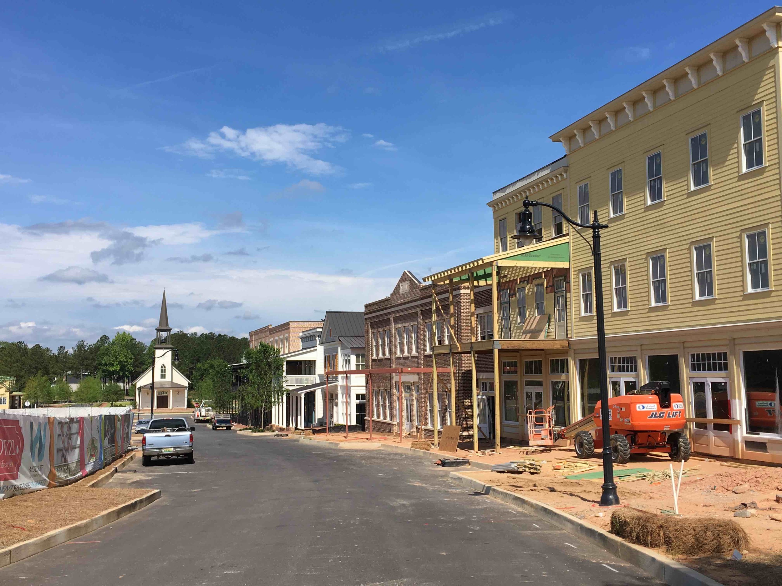
Old Town Columbus will feature a focus on walkability... but you'll have to drive to get there.
The city of Columbus is perhaps best known as the site of Fort Benning and home of the Aflac duck, as the eponymous insurance company is headquartered there. As with cities all over the country, it now features a rejuvenated downtown with lofts in former textile mills and the world’s longest (and perhaps most ferocious) urban whitewater course. There's lots of activity in the Columbus downtown.
So, where is the New Urbanist-inspired development of Old Town Columbus? It's actually more than nine miles away from the city’s historic downtown and its largest employers. To make matters worse, it is surrounded by high-speed roads that are being widened.
The marker at upper right shows the location of Old Town Columbus, the new development. Downtown and its whitewater course are lower left. Click on the image to view larger.

One of the roads bordering the Old Town Columbus development. Note that this road’s width will soon more than double.
Is this really a problem? If the goal is sustainability, whether environmental or economic, yes. These projects, while apparently inspired by New Urbanism, do not conform to this important CNU canon: "The physical organization of the region shall promote transit, pedestrian and bicycle systems to maximize access and mobility while reducing dependence on automobiles and trucks." True, residents will likely walk to shops and restaurants once they get home in the evening, but before that, they will be part of the hordes of single-occupant car commuters jamming the highways and polluting the air.
Where is the attention to the region beyond the development as called for by CNU? As traffic worsens, how likely are such isolated developments to remain economically viable? After all, real estate trends show that people are moving to locations that are more convenient to where they work: the formerly abandoned downtowns of major US cities.

Home price changes in the metro Washington, DC region. Note how the highest growth has been in the central core. (Courtesy of The Washington Post and Federal Housing Finance Agency)
Yet, even when a development is in a suburb served by transit, neither the developer, nor local politicians and planners will give any thought as to how people in these walkable developments will access transit without a car. An excellent example of this oversight is the Mosaic District in Fairfax County, VA. This development just outside the Beltway to the west of Washington, DC, is chock full of residences, shops, and parking garages. There’s even a state-of-the-art theater. It’s a wonderful place to visit on the weekends, but you’ll need divine intervention to reach it during weekday rush hours.

A key entry point to the Mosaic District. These drivers are trying to access the large, free parking garages within the development.
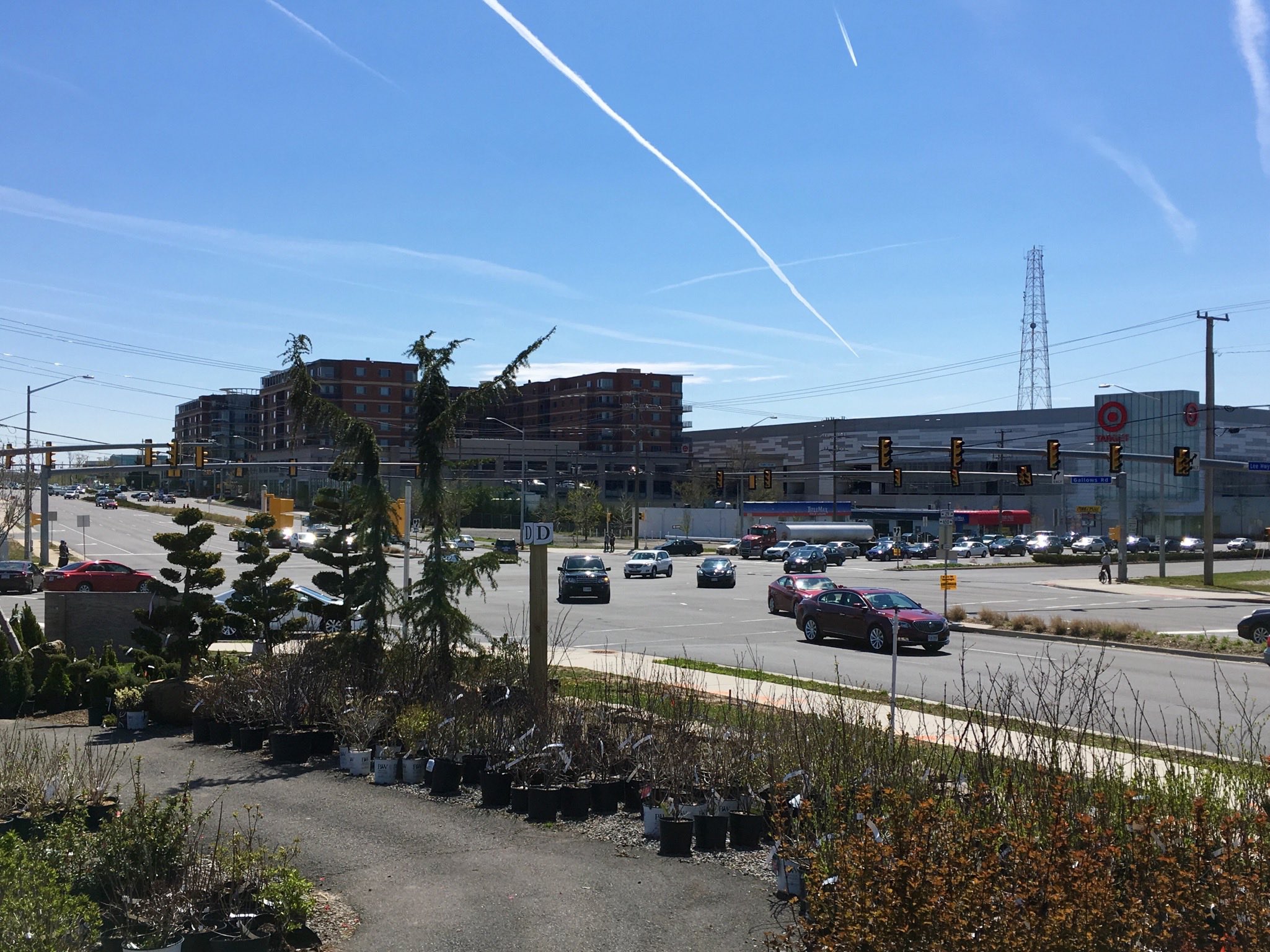
To reach the Mosaic District from the nearest Metrorail station, you must traverse this intersection. Good luck!

Street through Penn Quarter in downtown Washington, DC: all the livability of a suburban, New Urbanist-inspired development, but with none of the commuting hassle. (Photo courtesy of Google Streetview.)
That’s because the development is surrounded by stroads — streets widened to multiple high-speed lanes, gentle turning radii, and crosswalks as wide as some downtown blocks are long. Ironically, the development is within walking distance of a Metrorail stop, but few are brave enough to cross intersections such as the one at US 29 and Gallows Road (above). To reach the rail station, pedestrians must cross a total of nine lanes of traffic. Some of these lanes were added to accommodate increased volume due to a nearby HOT lanes access point to the Beltway. That gives you an idea of what the priorities of Fairfax County and Virginia DOT officials are: cars come first and pedestrians come second.
Contrast this with Penn Quarter (see the photo on the right), an area of downtown Washington that has seen a great deal of redevelopment in this millennium. Again, bustling restaurants, shopping, and high-density residential development abounds. But, unlike Mosaic, this area has direct access to Metro. The streets have bike lanes. Employment centers are within easy reach. Unsurprisingly, prices are also higher.
So if you are a potential homebuyer looking at condos in lively areas or a real estate investor comparing possible sites for redevelopment, where should you focus: suburb or downtown? If you look at the suburbs, you will notice that the infrastructure favors the car.
Millennials are not buying cars like previous generations did, and they are the current growth market for real estate. Why would they want to live somewhere that is car-dependent? If they can afford a downtown area like Penn Quarter, that is where they will go. They will likely choose the suburbs as a cheap, last resort rather than as a primary preference.
Downtowns, at least in large cities, have a competitive advantage over New Urbanist developments because they don’t require massive reengineering. They typically began life before the car and were adapted for it. The suburbs came along during the car’s heyday. Adapting them for people is a very costly undertaking. Given the problems experienced in places like the Mosaic District, I do not see any indication that either the finances or political will exists to fully make that change.
Related stories

About the Author
Kevin Posey is an advocate for sustainable transportation and urban development practices worldwide. He serves on the Capitol Trails Coalition in Washington, DC and on the board of the Virginia Bicycling Federation. He also is a licensed realtor. Previously, Kevin has written for Greater Greater Washington, the Virginia Bicycling Federation, Patch.com, and his own blog,Trafficsnark.blogspot.com.
Design doesn’t just reflect our values — it forms them. If we want citizens who are engaged, generous, and resilient, we need places that cultivate those virtues.