The Road Decides Where the Money Goes
%20(1).avif)
.avif)
I drive about 30,000 miles a year with five kids in the car, mostly to hockey rinks and cheer competitions. Somewhere in the middle of all that windshield time, I started building a database: every U.S. interstate exit, all 19,675 of them, and everything a traveler can reach from each one. About 750,000 places. Then I did the same thing for the old, two-lane routes the interstates replaced: US 1, US 27, and California's Highway 1, town by town.
I was building a road trip app. What I ended up with is a measurement of something Strong Towns readers already believe: the design of a road decides whether travel money stays in the community or leaves it.
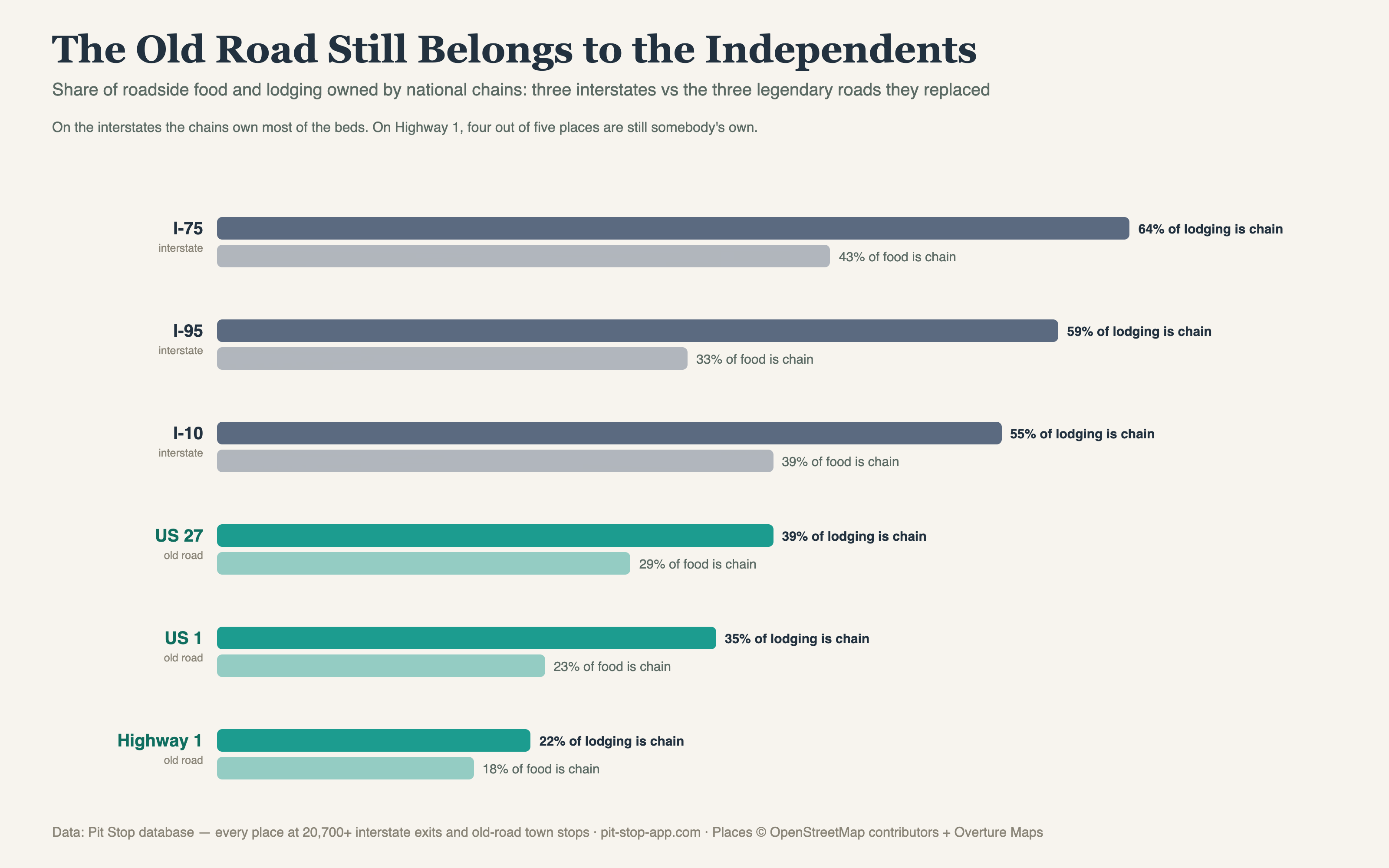
Here is the cleanest number in the dataset. On the interstates, national chains hold 55–64% of the roadside lodging. On I-75, it is 64%. On I-95, 59%. On the old routes those same travelers used to drive, the picture inverts: chains hold 39% of the lodging on US 27, 35% on US 1, and just 22% on Highway 1. On the old road, four out of five places to sleep are still owned by somebody who lives there.
Food tells the same story a little more softly: 33–43% chain on the interstates, 18–29% on the old routes.
Nobody legislated this. No town council voted to hand its roadside to national brands. The road did it. An interstate interchange is a real estate product with a specific shape: high traffic counts, cheap land at the ramp, and a customer who wants to be back on the highway in 11 minutes. That shape is a franchise pro forma. A national chain can underwrite an interchange location from a spreadsheet in another state, because every interchange is roughly the same place.
A two-lane route through a town square is the opposite kind of place. The traffic is slower, the buildings are old and oddly shaped, the parking is on the street, and the customer is somebody who chose not to take the interstate, which means they chose to be somewhere in particular. You cannot underwrite that from a spreadsheet. You have to live there. So the people who own the roadside on the old routes are, overwhelmingly, the people who live on them.
The second finding is about what happened to the towns themselves. I looked at which interstate corridors run along the paths of pre-1956 U.S. routes, the roads that existed before the Interstate Highway Act, versus corridors cut on new terrain. The difference is stark. Corridors that inherited an old U.S. route have roughly half the empty exits of the new terrain corridors. There is a clean gradient in the data: exits along old U.S. route corridors are empty about 9% of the time, exits along old state routes about 18%, and exits on roads that follow nothing at all about 23%.
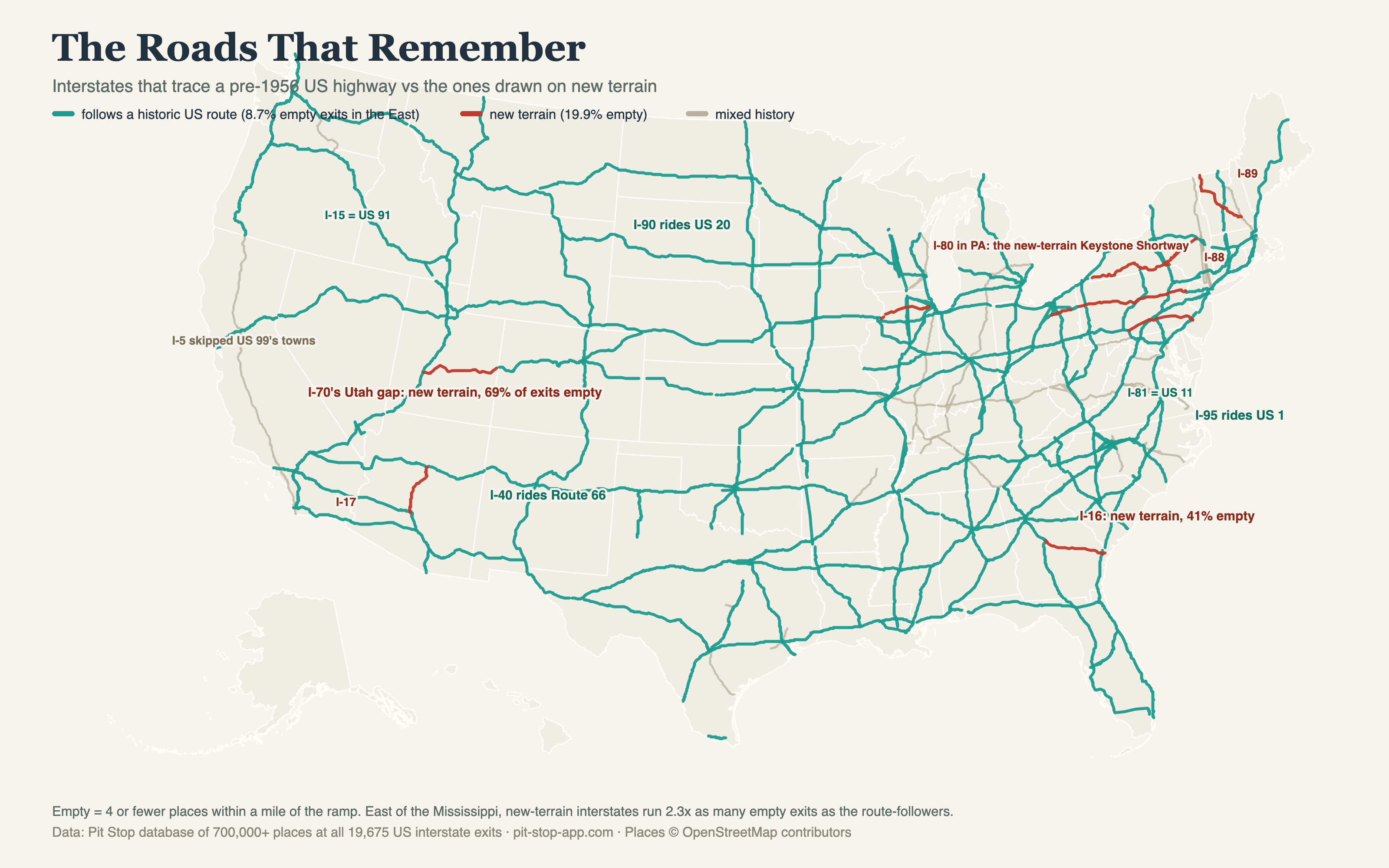
The roads that remembered their towns kept them. The pre-1956 routes existed because towns existed: the pavement connected places people already lived. When the interstate followed that same corridor, its exits landed near real communities, and those communities put gas stations and diners and motels on them. When the interstate cut new terrain in the name of efficiency, its exits landed nowhere, and mostly nowhere they remain, 70 years later. Infrastructure inherits. A road built to connect towns keeps producing town economies. A road built to bypass them keeps producing bypass economies, which is to say, chains at the interchange and silence in between.
I want to be careful about what I am claiming. This is not an argument that the interstates were a mistake. I use them constantly, usually with a kid asking, "How much longer?" It is an argument that we should see the old routes for what they still are: functioning economic infrastructure for local ownership. We tend to file them under nostalgia, scenic byways, antique signage, a Sunday drive. The data says they are something more practical. They are the last road network where an independent business can win the roadside, because the road itself — slow, particular, threaded through the middle of town — is the moat.
That has planning implications. A town on an old U.S. route holds an asset that no interchange town can buy back at any price: a main street that travelers pass through at 25 miles an hour. Every decision that makes that stretch better to stop on, the crosswalk, the angled parking, the reason to get out of the car, is economic development aimed at the one kind of traveler money that reliably lands in local pockets. And there is growing evidence that the travelers are coming back. When I publish maps from this dataset, they draw millions of views, and the comment sections fill with people planning trips down the old roads on purpose, asking which towns are worth the stop.
The great American road trip did not die. It moved one road over, onto the routes where the towns still own themselves. The numbers say the old road never stopped working. We just stopped counting what it does.
Jake Boyles is a software engineer and dad of five. He builds Pit Stop, a road trip app, and publishes free maps and data from it at pit-stop-app.com/blog.
%20(1).avif)
%20(1).avif)
%20(1).avif)
%20(1).avif)